Digby Area · Trails, Lighthouses and Open Spaces
April 2020, course «Thematic Project» at the Centre of Geographic Sciences
In the last semester of the Geographic Sciences program (Cartography concentration) at the Centre of Geographic Sciences, students work on a individual thematic project. I worked on a foldable map for the Digby region showing hiking trails, lighthouses and other open spaces.
Digby is very important for my dream to come to Canada and I wanted to give something back to the region. That's why I approached Jonathan Riley from the Municipality of the District of Digby and Greg Turner from the Digby Area Tourism Association in Autumn 2019 with the idea of a map for the region. They both liked the idea and I started the project in January 2020.
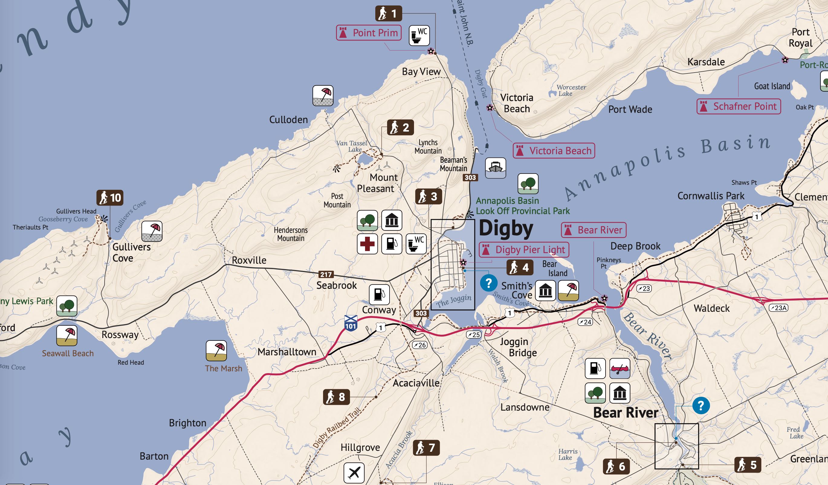
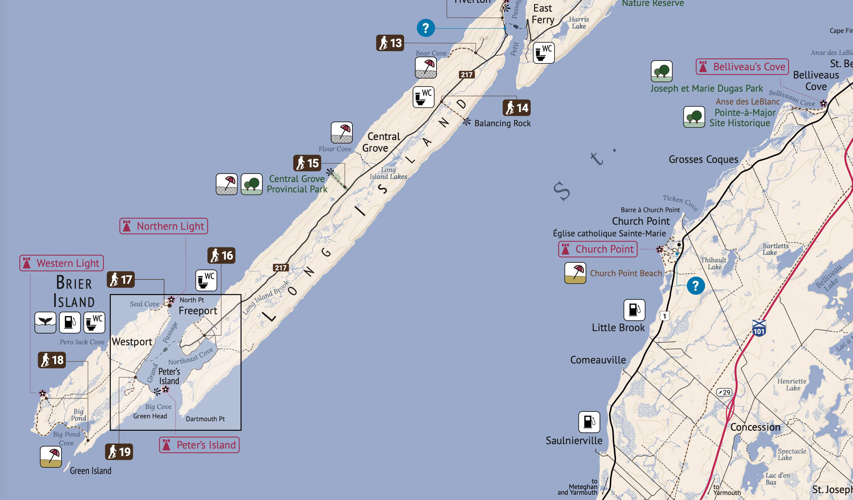
The map is used in tourism and recreation and focuses on the hiking trails in the Digby region. The map also shows the locations of the lighthouses and other open spaces such as beaches and parks.That said, the map provides an overview of various recreational activities in the region and acts as a tourist map at the same time. Although primarily intended for tourists, the map does also want to address local residents and other Nova Scotians.
Design Objectives
Presented map uses a simple design. Some colours such as for water features, parks and forested areas are related with the colours of a Swisstopo map. In addition, a burgundy-like colour and brown were used. They harmonize well with the other colours. For labelling, the fonts PT Sans, PT Sans Narrow and Lora are used. Lora was chosen for its subtle cursiveness of its italic font style. However, PT Sans’ and Lora’s digit 1 has a serif which did not look well in map shields. Therefore, the font Roboto is (solely) used for numbers.
There are three main features, hiking trails, lighthouses and other tourist features such as parks, whale watching, canoe launching, beaches, washrooms and other facilities. A brown colour (earth) is used for the hiking trail labels and a burgundy-like colour for the lighthouse labels. Lighthouse labels are not filled in order to not appear more prominent than hiking trails. All other features use classic icons. Most of those icons should be familiar to most map readers. However, this map is using a gender neutral washroom icon at the request of the client. After some research it was obvious that only a toilet or the lettering WC is commonly accepted to use by the community. However, using a toilet seat makes the icon too prominent whereas using the lettering WC is not well-known in North America. Therefore, a combination is used.
The map is inclined by 8 degrees so that Brier Island and Annapolis Royal fit on the map sheet. Although Annapolis Royal is located in another county, it is important for a map reader’s orientation because of its highway exit 22 which connects Digby with the south shore of Nova Scotia and the national park.
There are four inset maps and one access map. All inset maps are inclined by 8 degrees as well to be consistent and also have the inset boxes on the main map parallel to the margin. Due to their larger scale, the inset maps show additional features such as forested areas and larger buildings. There is one smaller scale access map for New France to overcome the fact that the dry weather road connecting New France with the rest of the map is just outside of the paper’s margin.
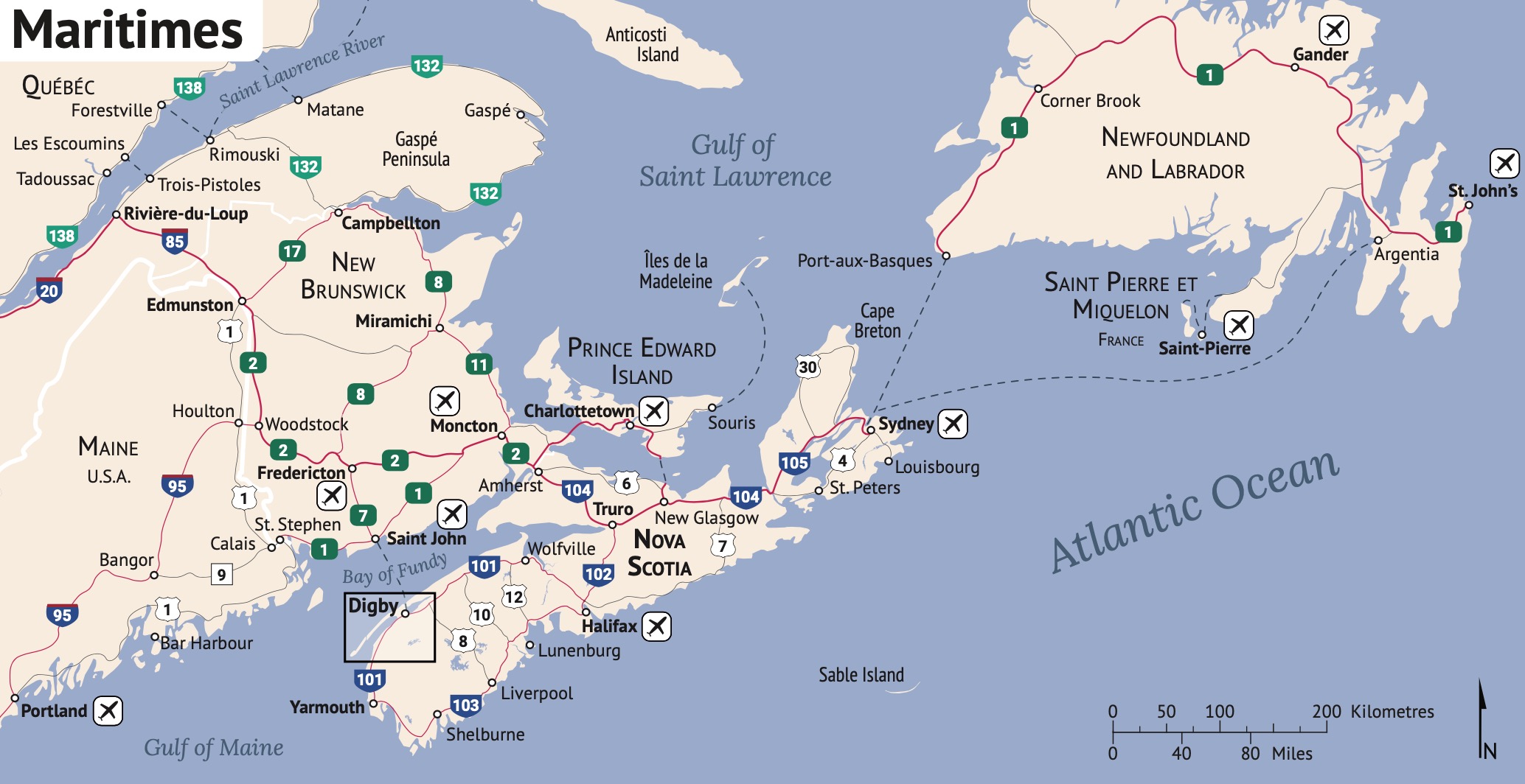
The folding concept is similar to the 2015 Highway Map of PEI. The inset maps were placed in a way so that the user can access them quickly with only two unfolding steps. There is also an overview map of the Canadian Maritimes which provides essential information on how to come to Digby.
The trail descriptions are accompanied by additional icons to provide a quick overview for the map reader. The icon set was created by myself whereas these awesome trail descriptions were written and provided by Jonathan Riley .
Trail 11
There was apparently a misunderstanding regarding trail 11 and it needed to be removed from the map in June 2021. Trail 11 is not open to the public. If you have an older version of the map, please do not hike trail 11.
Printed Map
In Spring 2021, the Digby Area Tourism Association printed 5,000 copies of the map. Printed maps are expected to be available in the Visitor's Information Centre in Digby in Summer 2021. Until then, you are welcome to download the PDF from this site or from www.digbytrails.ca.
Note: The printed map needed to be revised after it was printed because trail 11 is not open to the public. See above. Therefore, the printed map uses stickers to hide the information about trail 11.Awards
- 2020 President's Prize / Prix du Président (2020)
awarded by the Canadian Cartographic Association - Certificate of Achievement Excellence (2020)
awarded by the Digby Area Tourism Association (DATA)
Copyright, Sources, Disclaimer
© 2020-2021 Thomas Zuberbühler (Maps, Layout) and Jonathan Riley (Text)
Data Sources: Province of Nova Scotia, Government of Canada, District of Digby, AVTC Contains information licensed under the Open Government Licence – Canada.
Thanks to Jonathan Riley, Greg Turner, Greg Mosher, Martha Bostwick, Monica Lloyd, Heinz-Günther Sussdorf, Rick Jacques, the Digby Area Tourism Association and the Municipality of the District of Digby for their support and assistance.
Produced as a portion of the requirements of the Geographic Sciences Program at the Centre of Geographic Sciences, NSCC, Lawrencetown, Nova Scotia.
This product is for informational purposes only and may not be complete or accurate.
Use at your own risk.
Software, Technology, Data Sources and Skills
- Adobe Illustrator 2019
- Adobe InDesign 2019 (for layouting)
- ArcGIS for Desktop 10.7 and Mapublisher 10.5 (to bring spatial data into Adobe Illustrator)
- Adobe Photoshop 2019
Links